


Small Unmanned Aerial Systems (sUAS)
 Civil Air Patrol boasts the largest Small Unmanned Aerial Systems (sUAS) program in the United States. Illinois Wing was one of the first five units in the nation to adopt this exciting program, acquired drones and began training remote pilots back in 2016.
This page was designed to brief our members, prospect members, and (more importantly) other entities such as government organizations, fire departments, police department and similar that may be in need of such resources for remote imaging, search and rescue and disaster recovery.
Capabilities
-
Aerial Search & Rescue (SAR)
-
Remote Aerial Imaging (search patterns or adhoc)
-
Infrared & Thermal Imaging (FLIR) for locating missing persons\vehicles
-
Aerial Radio Direction Finding (Frequency/Mode Agile)
-
-
Disaster Recovery
-
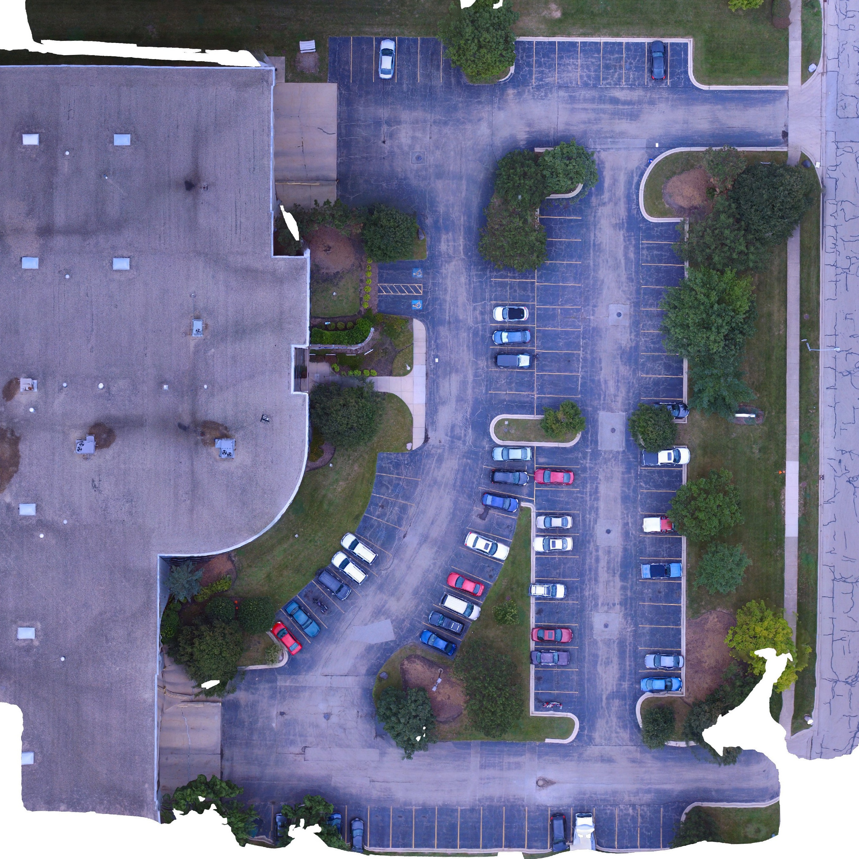
Orthophotomosaic Imaging of both large and small scale image mapping (6 centimeter resolution)
-
Infrared & Thermal Imaging (FLIR) for locating victims
-
Equipment
The following drones are either immediately available for mission deployment or can be requested as-needed (sometimes in 1 day delivery time for bonafide missions):
|
IMMEDIATELY AVAILABLE |
||||
|
MAKE |
MODEL |
TYPE |
DURATION |
CAPABILITIES |
|
Skydio |
Skydio 2 (Enterprise Kit) |
Quadcopter |
23 Mins |
12 MP HDR Photos and 4K60 HDR Video |
|
RC Timer |
F800 |
Hexacopter |
12 Mins |
Large camera platform, >5lb payload |
|
DJI |
Phantom 3 Pro |
Quadcopter |
28 Mins |
4K/12MP Camera, Aerial Radio Direction Finding (frequency agile) |
|
DJI |
Phantom 3 |
Quadcopter |
28 Mins |
2.7K/12MP Camera, Aerial Radio Direction Finding (frequency agile) |
|
DJI |
Mavic Mini |
Quadcopter |
28 Mins |
2.7K/12MP Camera, tiny portable, rapid deployment |
|
AVAILABLE UPON REQUEST |
||||
|
MAKE |
MODEL |
TYPE |
DURATION |
CAPABILITIES |
|
DJI |
Phantom 4 Pro |
Quadcopter |
25 Mins |
4K/12MP Camera, 1 unit equipped with multi-spectral cameras (R,G,B, O, Cy, NIR) – 20MP MAPIR Survey 3 cameras |
|
DJI |
Mavic 2 Enterprise Dual |
Quadcopter |
30 Mins |
Dual 4K/12MP EO camera with 160x120 IR sensor, Has mountable speaker and spotlight |
|
InstantEye |
MK-3 Gen4 |
Quadcopter |
30 Mins |
ISR\HLS Version, Gimbaled 4K EO camera w\ 640x512 IR, Can mount MAPIR Survey 3 20MP camera, AFSOC approved non-COTS sUAS (DOD use), Mount to carry/drop 3lb object (20 mins) |
|
DJI |
Inspire 2 |
Quadcopter |
30 Mins |
Zenmuse X5S Camera (5.6K, 20MP camera), 1 downward sensor, Images are georeferenced |
|
Skylark |
Endurance Quadcopter |
Quadcopter |
40 Mins |
MAPIR Survey 3, 20MP (R,G,B) camera which can be interchanged to multispectral |
|
DJI |
Matrice 210 RTK |
Quadcopter |
35 Mins |
Real Time Kinematics, 2cm GPS accuracy, 1 upward or 2 downward sensors, Z30 Camera 5K+\20 MP, 30x Optical (6x Digital) for 180x zoom, ZXT2 4K/12 MP camera w/ 640x480 IR |
|
Event 38 |
E384 |
Fixed-wing |
90 Mins |
Sony R10C 20MP mapping camera, Size and flight characteristic similar to RQ-11 Raven |
Requesting Services
If you are a government agency, fire department, police department or similar in need our Small Unmanned Aerial Systems for imaging, search and rescue, or disaster recovery, please don't hesitate to contact us. In many cases we already have a Memorandum of Understanding (MOU) in place with agencies across the state of Illinois... but if not, let's begin the dialog. Please scroll down to the "Contact Us" section below to make your request. We are ready to assist you.
Training
CAP members, check back here soon for updates here on how you too can get licensed and qualified to participate in our drone program. Updates should be posted in November 2019.
Program Updates
Our program is rapidly evolving as we board board more resources, regulations change and technology advances. Therefore our national headquarters is constantly updating our strategies; You can view the latest program briefings on their webpage at:
Contact Us
If you have questions or comments please feel free to contact our Small Unmanned Aerial Systems Officer:
Capt Gary Brown
EMAIL: gbrown@ilwg.cap.gov
PHONE: 630-660-8231